FEMA Flood Maps: Better Planning and Analysis Needed to Address Current and Future Flood Hazards - Government Accountability Office
What GAO Found
The Federal Emergency Management Agency's (FEMA) Risk Mapping, Assessment, and Planning (Risk MAP) program has increased its development of flood maps and other flood risk products, but faces challenges ensuring they comprehensively reflect current and future flood hazards. For example, its flood risk products do not reflect hazards such as heavy rainfall and the best available climate science. These products include maps—known as Flood Insurance Rate Maps—and nonregulatory flood risk products such as estimates of flood damage in an area. FEMA's Risk MAP program is addressing some of these challenges, but many may require years to address. However, Risk MAP has been operating under an out-of-date plan that does not reflect new goals, objectives, activities, performance measures, and associated timeframes. Updating its program plan to include these elements could help FEMA effectively manage and coordinate its efforts to incorporate current and future flood hazards in a timely way.
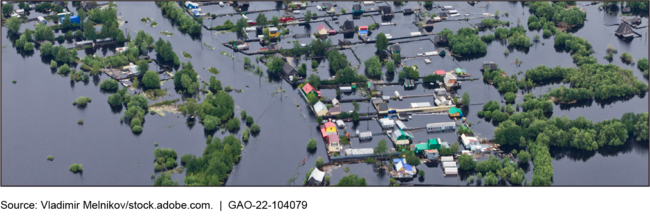
Example of River Flooding
FEMA does not periodically assess the usefulness of its nonregulatory flood risk products, which are intended to help communities increase their resilience to floods. According to FEMA, it has invested millions of dollars in developing Risk MAP nonregulatory products; however, the agency has not assessed the usefulness of these products in increasing community resilience since 2016. Establishing mechanisms for periodically assessing the usefulness of its nonregulatory products could help FEMA ensure it is investing in products that address community need and have a meaningful impact on enhancing flood resilience.
FEMA prioritizes mapping projects with input from all levels of government and FEMA regional offices, but could better use available data to inform its mapping efforts. FEMA's decision-making process has emphasized directing resources to areas with greatest flood risks. Additionally, in 2020, FEMA established a strategic priority for considering socially-vulnerable populations as part of disaster resilience. According to GAO's statistical analyses of data from the Risk MAP program and FEMA's publicly available disaster risk assessment tools, FEMA's mapping investments for fiscal years 2012 to 2020 were greater where flood risks were higher, but were lower for areas of higher socially-vulnerable populations. By considering ways to leverage available data into its annual process for prioritizing its flood mapping investments, FEMA could enhance its ability to make well-informed decisions that meet agency and federal priorities and disaster resilience goals.
Why GAO Did This Study
FEMA is responsible for producing and updating Flood Insurance Rate Maps and nonregulatory products to show areas of greatest flood hazards and help guide floodplain management actions under the National Flood Insurance Program. While FEMA has mapped millions of miles of the nation's streams and coastlines, questions have been raised about whether its flood risk products provide a comprehensive picture of flood risk.
The Additional Supplemental Appropriations for Disaster Relief Act of 2019 required GAO to review issues related to 2018 disasters. As part of this body of work, this report addresses (1) the extent FEMA has developed Flood Insurance Rate Maps and nonregulatory products that reflect current and future flood hazards, (2) the extent FEMA has assessed its efforts to enhance flood resilience, and (3) how FEMA prioritizes its mapping resources to create and update Flood Insurance Rate Maps. GAO reviewed agency documents and strategic plans; analyzed FEMA data; and interviewed FEMA, selected states and localities, and flood mapping experts.

Comments
Post a Comment